

Your study Bible has the wrong location for the crossing of the Red Sea
They crossed the Gulf of Aqaba, which is part of the Red Sea

Informal thoughts on the crossing of the Red Sea
Exodus 14:1-15:21
Record of the actual crossing of the Red Sea - now we’re told that the people came up against the Red Sea, had the Red Sea in front of them and the armies of Pharaoh closing in from behind - this is what God had said: 4 And I will harden Pharaoh’s heart, and he will pursue them, and I will get glory over Pharaoh and all his host, and the Egyptians shall know that I am the Lord.”
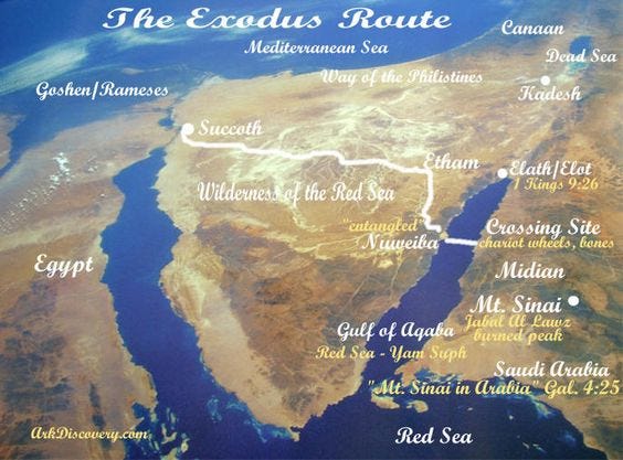
The research - mostly following the work of archeologist Ron Wyatt - indicates to me that we’ve had the location of the crossing of the Red Sea all wrong, and almost all of the maps in our study Bibles are all most likely wrong -
The most likely route is that after they left Egypt, they went around some small, shallow lakes in northern Egypt, and then followed a trade route across the Sinai Peninsula - and they followed that trade route until God directed them to turn south - remember he was directing their path by the pillar of cloud by day and a pillar of fire by night - so suddenly the pillar of cloud turns toward the south and takes them and to a wadi, that’s a word for a dry river bed - and they follow it all the way until they hit the Red Sea at the Gulf of Aqaba -
The Gulf of Aqaba is one of the two fingers of the Red Sea going north from the main body of the Red Sea - look at a map, the finger on the left is the gulf of Suez - where they built the Suez Canal - that runs due north to the Mediterranean Sea - the finger on the right is the Gulf of Aqaba - now the Gulf of Aqaba is part of the Red Sea, so you cross the Gulf of Aqaba, you’ve crossed the Red Sea - and it’s my suggestion that they crossed the Red Sea by crossing the Gulf of Aqaba -
On the other side of the Gulf of Aqaba is Arabia - that’s where I believe they drank water from the rock and where Moses received the 10 Commandments on the top of Mt. Sinai - there is a mountain there called Jebel el-Lawz that I believe is the real Mt. Sinai - and it’s got an interesting feature- the top of this mountain has been scorched black - like it had been hit by big-time lightning strikes and burned -
Now the maps in our study Bibles have all these sites located on the Sinai Peninsula, which is not in Arabia, it’s in Egypt - but Paul himself even says in Galatians that Mt. Sinai is located in Arabia - so this version would be truer to the biblical account -
Now this wadi, this dry riverbed, follows a winding, serpentine route that takes you right down to a huge beach right on the edge of the Gulf of Aqaba - this beach is about five miles long, and wide enough it could probably accommodate about 2 million people at any time - so my suggestion is that the sons of Israel camped on this beach before they crossed - I’ve include a map that traces this route -
And then the armies of Pharaoh finally caught up to them, and Pharaoh’s boys start heading down this dry riverbed right going right after them - you can see pictures of this wadi, this dry river bed, it makes its way down from the desert plateau and dumps you right on this beach, called Nuweiba - it’s still there, only now it’s a tourist hot spot with hotels and stuff -
So they hear the chariots of Pharaoh coming down this dry riverbed, and they realize they are trapped - sitting on this beach with the hordes of Pharaoh riding right down on them - so they have Red Sea in front of them and the armies of Pharaoh behind them -
A strong east wind was responsible for pushing the waters back and creating a wall of water on either side - so the miracle is God using an element of nature and intensifying it until something spectacular and obviously supernatural occurred -
Wind blew hard enough, long enough, to push water, create kind of a wall, hold it there -
Where did crossing occur? Some: one of lakes right near Egypt - so why did people settle for these locations when none of them involved the Red Sea?
Touches on location of Mt. Sinai - most: southern end of Sinai Peninsula - don’t think so
Best reconstruction is that the sons of Israel followed a trade route across across Sinai Peninsula, all the way til they reached the Gulf of Aqaba
God led them down this wadi, this drive riverbed, to Nuweiba Beach - where everybody thought they were trapped -
Nuweiba Beach - on Gulf of Aqaba - it’s full name is the Waters of Moses - which is part of the Red Sea, an arm of the Red Sea - 5 miles long, room for 2 million people, wadi leads down from high desert - today: resort hotels and stuff
Land bridge that goes all the way across the Gulf of Aqaba - you can see it from the air, NASA satellites images show it - about 1/4 mile wide all the way across - the depth of the Red Sea is 6000’ deep on one side, 5000’ deep on the other - almost as if God had been preparing this geological feature for something like this - archeologists have also discovered Egyptian chariots and chariot wheels and even skeletons have been found - so the question is how they get there? Exodus 14 has the answer -
The Red Sea there is 10 miles across, 5% grade on this land bridge to the bottom of Gulf, 5% grade up to landing spot on the other side -
Solomon erected two pillars to commemorate, one on either side of the Gulf, one of them still standing on the Arabian side of the Gulf - if you were to visit this beach today you’d see one of the columns still upright - the one still standing has an inscription which contains the name of Pharaoh, the name of Moses, the name of Israel -
The true Mt. Sinai probably not Jebel el-Musa, as our study Bibles have it, but Jebel el-Lawz in Arabia - Paul says in Galatians quite directly that Mt. Sinai is in “Arabia” -
The whole top of this mountain is scorched black, like, you know, maybe somebody blasted it with some lightning strikes or set it on fire -
Great detail and good archaeological evidence, thanks for the info, brother Bryan!
I absolutely agree. Thank you for posting this.